Niku Expeditions Reference Kit

 Follow the research, planning, and operations for expeditions with this kit. Includes:
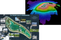
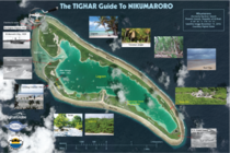
- A printed 11 x 17 Grid Map based on the July 18, 2012 GeoEye satellite image. The Grid Map is annotated with locations and features such as the abandoned village, the landing channel, the shipwreck, the former Coast Guard Loran station, the Seven Site, and others. This Grid Map also includes offshore areas that were the subject of underwater search operations during Niku VIII.
- A download of a high-resolution (800 dpi) JPEG of the Grid Map which can be zoomed in to reveal far more detail than is available in the 2007 image on Google Earth.
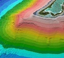
- A download of a selection of spectacular sonar maps of the underwater search area acquired during the Niku VII expedition. The maps are usable for research, wallpaper, screen savers, etc.
TIGHAR Members receive a 20% discount on this item.
This product includes the following digital media:
Downloads
Expedition Reference Kit Grid Map (46.55 MB)
Seabeam01 (1.38 MB)
Seabeam02 (2.65 MB)
Seabeam03 (4.42 MB)
Seabeam04 (4.57 MB)
Seabeam05 (4.34 MB)
Seabeam06 (3.29 MB)
Seabeam07 (3.30 MB)
Seabeam08 (3.95 MB)
Seabeam09 (2.77 MB)
Seabeam10 (4.18 MB)
| Media Type | Shipped Product |
|---|
You might also like...


People who purchased this also purchased...
$50.00